
| | | | Chapter 8
TRACKING A STORM ACROSS THE COUNTRY
Goals: To use surface pressure and temperature maps, 500-mb
height and absolute vorticity maps, and satellite images to
follow the development and maturation of a mid-latitude low
pressure system and attendant fronts across the United States.
|
Data:
Satellite images and surface and upper-air maps from an
extratropical cyclone that moved across the United States from
April 30, 1997 to May 3, 1997.
The "Sfc Pressure/Temp" maps
show isopleths of both sea-level pressure (in millibars) and
temperature (in degrees Fahrenheit). Isobars
are the solid lines, with labels on the left side, while
isotherms are dashed, with labels on the right side. Maxima
and minima of both fields are also labeled. Some additional labels
are also shown to aid in answering some questions.
The "500-mb Height/Vorticity" maps
show isopleths of both 500-mb height (in meters) and
absolute vorticity (in 10-5 per second). Contours
are the solid lines, with labels on the left side, while
"isovorts" (lines of equal absolute vorticity)
are dashed, with labels on the right side. Maxima
and minima of both fields are also labeled. Some additional
labels are also shown to aid in answering some questions.
To help students complete the exercise efficiently, the questions
associated with a particular time are also shown below the maps
for that time.
Procedure:
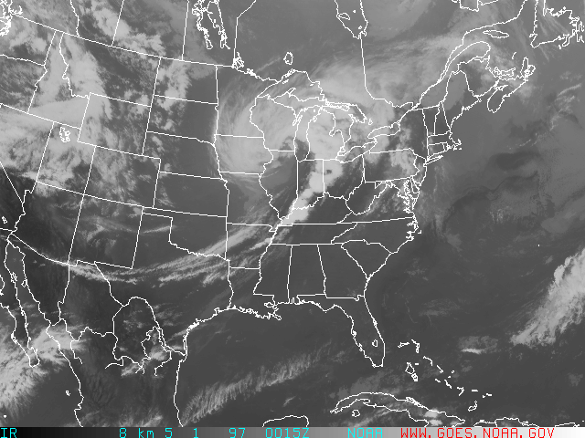
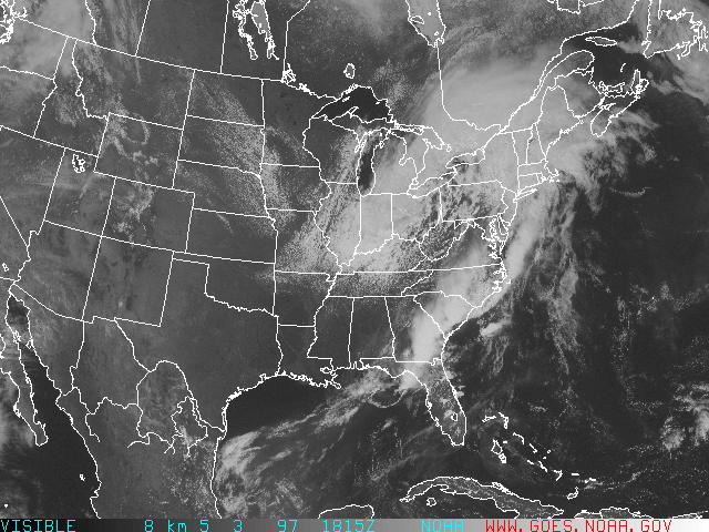
Though there is an impressive cyclone over the Great Lakes in late
April (see
18Z April 30 visible satellite image
and 00Z May 1 infrared image),
this exercise will focus on a system that traversed the
nation from the Western states to the East during the first few days of
May 1997.
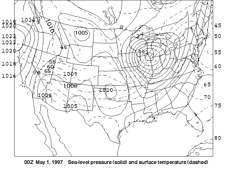
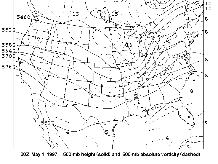
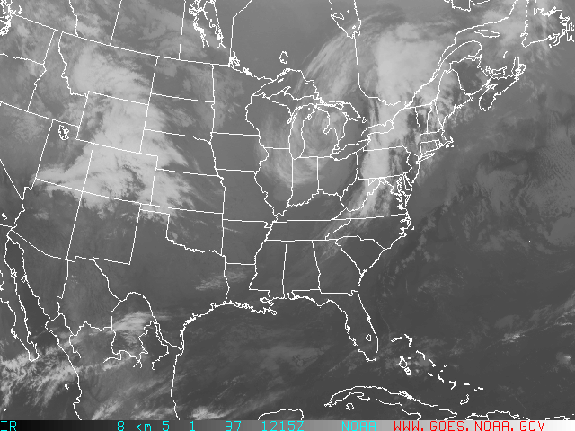
00Z May 1
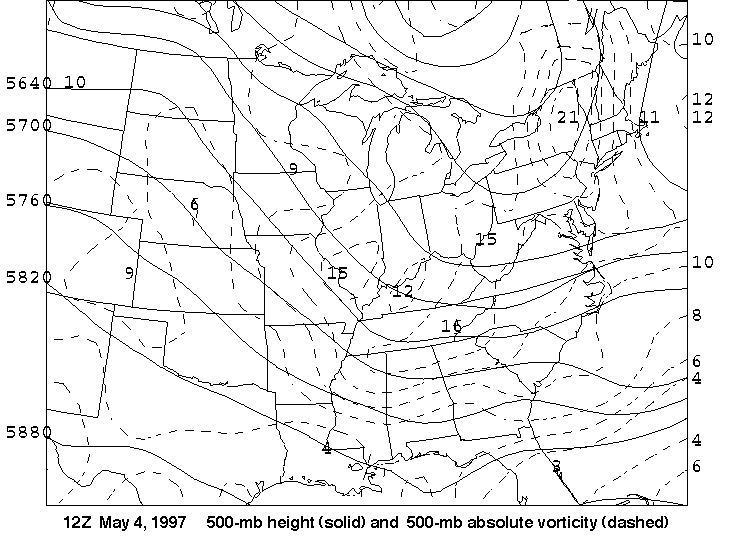
- On the
500-mb height/vorticity map
at 00Z on May 1, a trough of low
pressure has pressed inland over Washington and Oregon from the Pacific
Ocean. It is marked by a closed center of maximum absolute vorticity
(maximum value 17x10-5 sec-1). Note that the
trough is not easily detectable just by
looking at the 500-mb heights - the lines do not sag equatorward in the
typical way we normally think about troughs. Keeping this in mind and also
recalling the definition of relative vorticity, which effect do
you think is more important in generating this vorticity maximum at this
time - curvature or horizontal wind shear (see Figure 8.20)?
- Where would you look to find the surface low pressure system associated
with this absolute vorticity maximum - to its east or to its west?
Briefly explain.
- Because of the disruptive nature of the Rocky Mountains and the
inherent problems involved in correcting station air pressures to sea-level
pressure, the surface low is not readily apparent on the
surface map at this time. So
let's try to find one! First note the 1010-mb isobar ridging east into
Idaho from the high pressure center just off the coast from the
California-Oregon border. Also note the 1009-mb pressure reading along the
Utah-Colorado border. This barometric reading is slightly higher than the
1008 isobar just to its south. So there's a relative high pressure in
Idaho and a relative high pressure along the Utah-Colorado border.
So it seems logical that there's relative low pressure between them. Near
what large city in northern Utah would you place this relatively
weak surface low? Is this low in the general
region you thought it would be in the previous question?
- As a check to your answer in the previous question, look at the
isotherms sagging slightly south
over northern Nevada (the 55oF, 60oF,
and 65oF isotherms) and the same three isotherms
bulging slightly north over Utah on the
surface pressure-temperature map.
These waves in the isotherms, although subtle, suggest cooler,
more northerly winds over northern Nevada and milder, more
southerly winds over Utah. Would
such a circulation of winds be consistent with a surface low
near the city in the previous question? Briefly explain your answer.
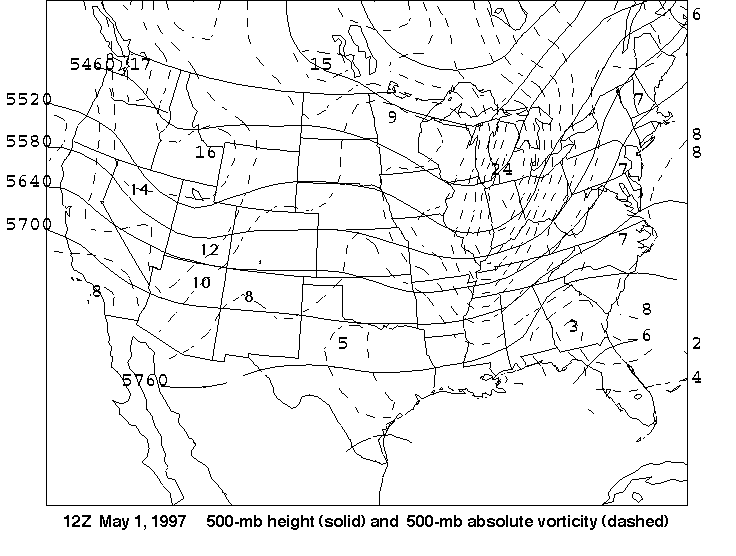
12Z May 1
- On the
surface map,
the surface low is now apparent. On the
500-mb height-vorticity map,
the trough is also now apparent (there is a definite
sag equatorward in the 500-mb heights over the Rockies). Do you think curvature has
become more or less important in generating relative vorticity associated
with the absolute vorticity maximum (of magnitude 16x10-5
sec-1 in eastern Idaho?)
- Before we leave the
500-mb height-vorticity map, there's another
vorticity center taking shape over the West, but it's not marked yet!
Let's see if we can find it! What is the value of the isovort going
through northwestern Arizona? Is the value of the absolute
vorticity near the juncture of the Nevada, Utah and Arizona borders
larger or smaller than the value of this isovort? Thus, conclude whether the
region in northwestern Arizona that is bounded by the dashed line is a
relative maximum or relative minimum in vorticity. Keep this in mind
as we go to the next set of maps.
- Use the surface map to determine where
the largest temperature gradient is in Nevada and Utah: in the
northern or southern half of these states? Recall that cold
fronts are typically
placed at the leading edge of the cold air (that is, on the
warm side of the zone of largest
temperature gradient). Is the linear cloud formation on the
infrared satellite image at this time
consistent with where the cold front should be placed?
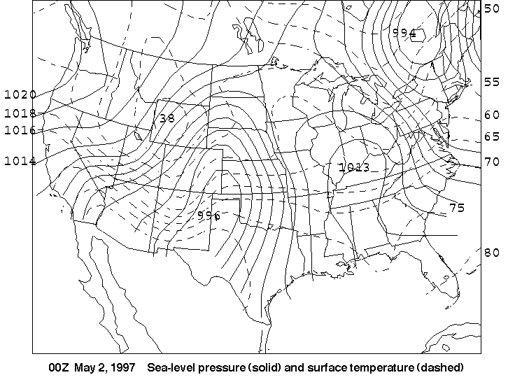
00Z May 2
- First, let's look at the
surface map. The low that was along the Wyoming-Colorado
border on the
surface map for 12Z May 1 has lost some
of its identity as it
moved into the Nebraska panhandle (it's no longer a closed low, but is
merely part of a surface trough extending over the southern high plains).
But there is another more impressive low taking shape over the Texas
panhandle that has apparently become dominant. In what state is the new
low's associated
vorticity maximum? What is the maximum value of absolute
vorticity of this vorticity maximum? Does this
result follow logically from your answer to the second question
of the previous section?
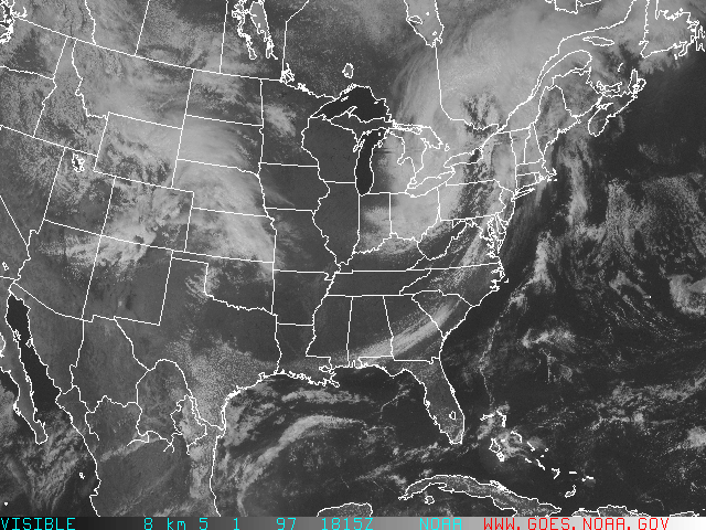
- The low over the Texas panhandle developed rapidly. Look at the
visible satellite image at 18Z on May 1.
Does the weather appear to be
active over Oklahoma (that is, do you see any evidence of thunderstorms)?
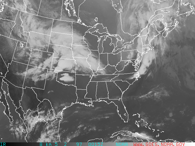
Then take a look at the
infrared satellite image at 00Z on May 2
(just 6 hours later). Is the weather now more active?
Briefly explain your answer.
- Can you make a broad generalization about a "weather symptom" of
rapidly deepening lows over the southern Plains in spring?
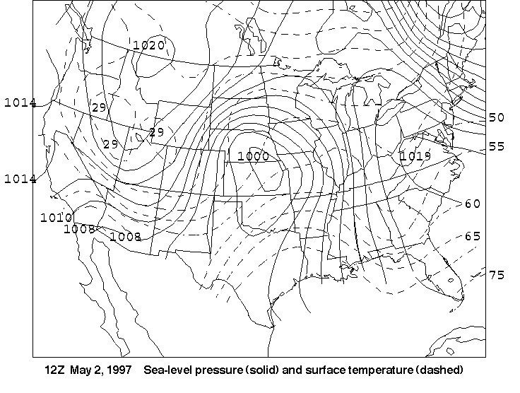
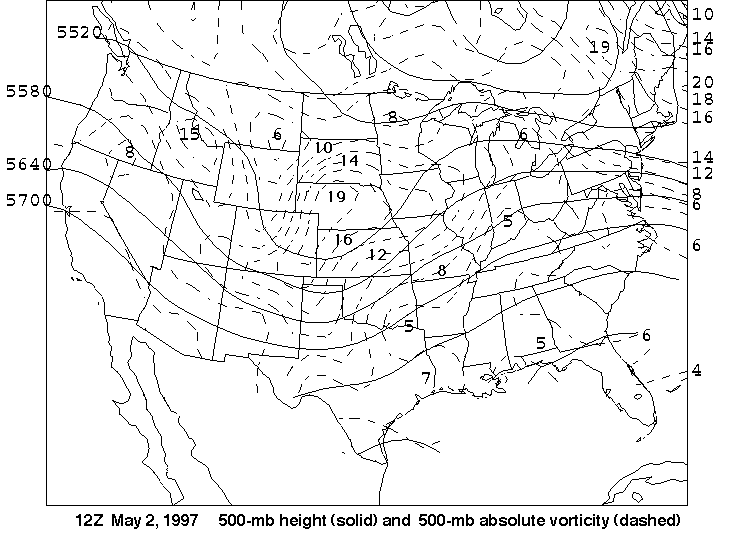
12Z May 2
- Having moved out of the Rockies and onto the Plains, the storm has now
consolidated into a single center of
surface low pressure with one, definitive
vorticity maximum at 500 mb.
Where would you place the center of
this vorticity maximum (give a specific location)? Give a reasonable
value of the absolute vorticity for this maximum.
- Are the relative positions of the
surface low
and 500-mb trough
consistent with the theory that you've learned in this chapter?
Briefly explain.
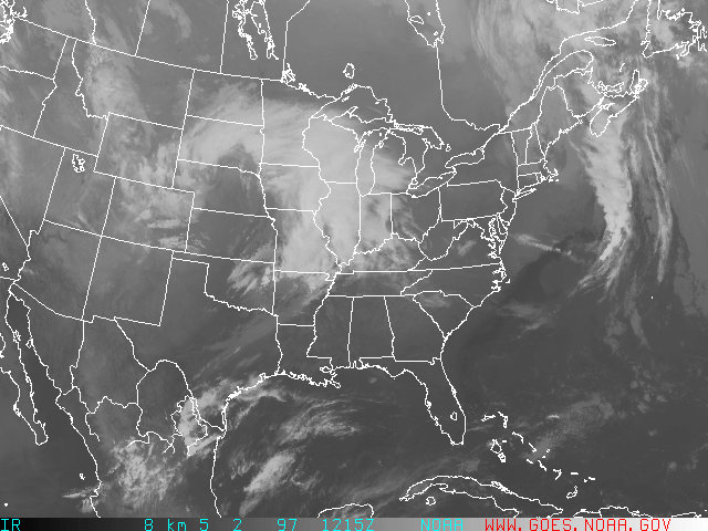
- On the
infrared satellite image,
look at the bright white clouds over
the western Great Lakes region. Keep in mind that the
surface low
and the warmest air associated with the system lie far to the south.
What type of clouds do you think exist over this region: cirrus or
cumulonimbus? What lifting mechanism do you think is primarily
responsible for generating these clouds: overrunning,
cold-frontal lifting, or surface-based convection
(recall the lifting model of a low pressure system in Figure
8.15)?
- What type of
clouds
(cirrus or cumulonimbus) do you think have formed in the extreme
northeastern corner of Oklahoma and also southern Missouri?
What type of front is likely playing a role in generating these clouds?
Is this cloud type consistent with the availability of moist air
from the Gulf of Mexico? Briefly explain, using the direction of
surface winds over northeastern
Oklahoma and southern Missouri to aid in your answer.
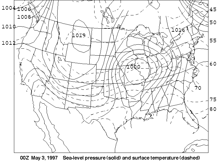
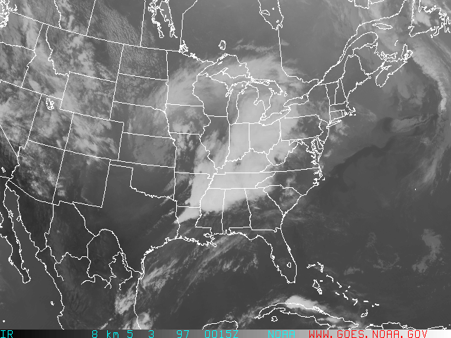
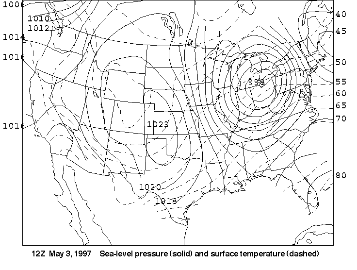
00Z May 3
- Recall that fronts are typically found in surface troughs. Thus,
the cold front at this time
extends from the surface low in northeastern Missouri to
___________ Arkansas and ____________ Texas, and then southwestward
to the central Rio Grande Valley of Texas (fill in the blanks
with a geographical reference for each of the states; for example,
northeastern or southwestern or central).
- On the infrared satellite image,
the vee-shaped thunderstorms in northern Louisiana are a signature
of severe weather. Such potent thunderstorms derive energy from
fast jet-stream winds. When updrafts of air rising within such storms
reach the tropopause (the boundary, or layer, between the troposphere
and the stratosphere, characterized by temperature remaining nearly
constant with height) and start to spread out horizontally, they have
relatively slow momentum compared to speedy high-altitude winds.
Like a "Sunday driver" on an interstate, the horizontally spreading
air that was once part of an updraft acts like a roadblock to the
faster high-altitude winds. So these fast jet-stream winds
divert around the Sunday driver, forming a vee-shape that forecasters
often use as a clue to detect severe thunderstorms. Now note that
the vee-shaped thunderstorms have erupted AHEAD of the cold front
(see cold-front placement in problem #1).
If you also look at the 12Z infrared image
on May 2, you will see that northeastern Louisiana received some
sunshine earlier in the day. Also note that warm
(and moist) air was available near the ground (see
surface temperature at 00Z for
verification). With these factors in mind, give an upper-air
mechanism that would have provided
favorable lifting for warm, moist parcels to rise high into the
atmosphere (hint: consider where the thunderstorms have developed
in relation to the approaching
500-mb trough).
- If you were to draw a dashed line through the
500-mb trough STARTING
with the middle of the sag in the 5520-meter height line over
eastern Kansas and EXTENDING to north-central Texas (use the sag
in the isovorts to help you as well), the trough
axis would slope from the _____________ to the ________________
(give compass directions here: choose your answers from N, NNE,
NE, ENE, E, ESE, ... , WNW, NW, NNW).
Such a slope is said to have a "positive tilt".
Later, we will see that a
"negative tilt" in the 500-mb trough axis is associated with rapid
deepening of the surface low. Stay tuned.
- In the meantime, we don't want to ignore the low's warm front.
Use the surface map to answer the
following: the warm front associated with the low passes near
what large city in southern Ohio?
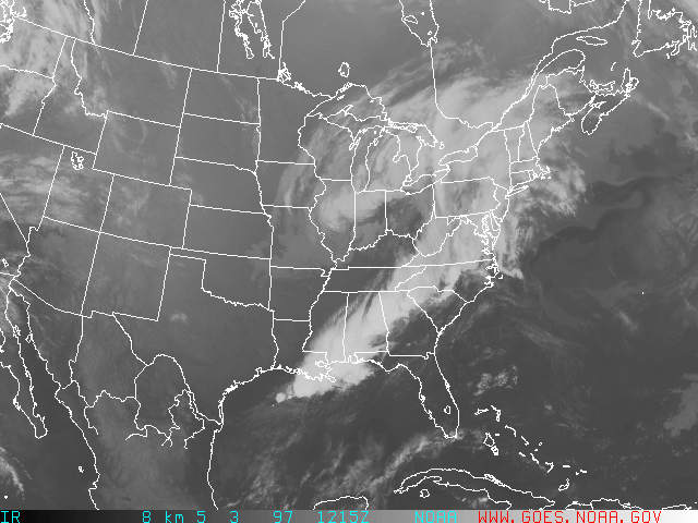
12Z May 3
- Now look at the
500-mb trough.
STARTING with the middle of the sag of
the 5460-meter height line, mentally draw a line through the
trough axis into northern Alabama (again, use the sag in the isovorts
to help you place the trough axis). Now the trough axis
tilts a bit from the ______________ to the ______________
(use the same directional headings as in question #3 in the previous
section). Such a slope in the 500-mb axis is
called a "negative tilt".
- Note the lower central pressure of the
surface low over the eastern
Great Lakes (compared to 00Z on May 3).
Obviously, the low has deepened by a few millibars. It seems that
the change in tilt
of the 500-mb trough axis went hand-in-hand
with the surface low's intensification. Apparently, the "negative tilt"
of the 500-mb axis provided increased _________________ aloft that
helped the low to deepen.
- Based on what you've learned previously, and using the
infrared satellite image, determine
where the most potent
thunderstorms are likely occurring at this time. What mechanisms
(both surface-based and aloft) are helping to drive these
thunderstorms?
- Note the classic "comma shape" to the clouds associated with this
system on the infrared satellite image.
The "comma head" over the Great Lakes region is primarily formed
by the cold-conveyor belt (see text) wrapping counterclockwise around
the low. Based on the infrared image,
how far to the south and west of the surface low do the low
clouds associated with the cold
conveyor extend (just give the name of a state for your answer)?
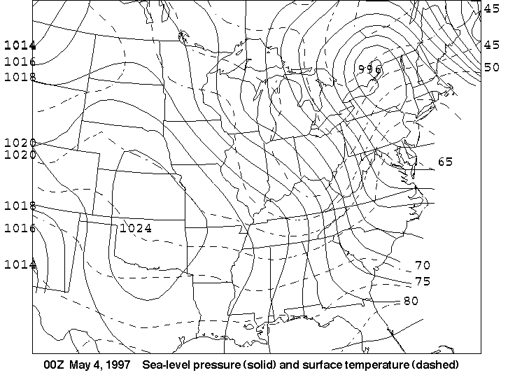
00Z May 4
- The first thing to note is that the large
500-mb trough
once associated with the surface low
(which is located along the New York-Canada border at this time)
is hanging too far back over the Great
Lakes to provide much in the way of upper-level divergence for the
surface low. This begs the question: how can this 996-mb low exist
without divergence aloft? The answer, of course, is that the low
HAS some upper-level support. Where is the vorticity maximum
that is providing some divergence aloft for the surface low
(give the vorticity maximum's location and its maximum value
of vorticity)?
- Is there a clear-cut trough in the
500-mb height lines associated with
this vorticity maximum? If not, which term (curvature or horizontal
wind shear) must be hard at work generating the necessary cyclonic
vorticity?
- Are the surface low
and this 500-mb vorticity maximum
nearly "vertically stacked"? That is, does it appear that this
vorticity maximum is getting close to being directly above the
surface low?
- Based on the relative positions of the
surface low and this
500-mb vorticity maximum
at this time, do you think that divergence aloft over the low has
become less or more optimal over the last 12 hours?
- Keeping your answers to these last two questions in mind,
do you expect this surface low to weaken over the
next 12 hours (that is, would you expect its central pressure to
rise)?
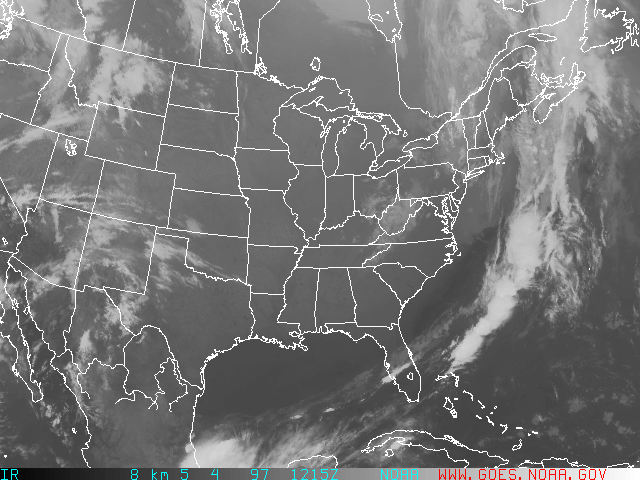
12Z May 4
- At this time, the surface low
is centered near the St. Lawrence River Valley to the north-northwest
of Maine (the center of the low lies off the
map, but you should be able to answer the following question based on
the value of the last isobar partially shown in the upper-right
corner of the map). Determine whether the central
pressure of the low is less than, greater than, or about the same
as (defined for our purposes as within 2 mb of) the central pressure
that was observed at
00Z on May 4?
- Looking at the
500-mb height/vorticity fields at
this time, can you
explain why the low didn't weaken as much as you might have
thought it would (recall your answer to #5 at 00Z May 4.)
Hint: Base your discussion on the main
500-mb trough, which,
12 hours earlier, appeared to be hanging
far west of the surface low.
Unlike previously brief answers, your explanation will likely
take a couple of sentences to describe what happened and why.
Other "Weather on the Web" Exercises
Chapter 1 |
Chapter 2 |
Chapter 3 |
Chapter 9 |
Chapter 10|
Chapter 11 |
Chapter 12 |
Chapter 14